Climate Explorations of Weather Extremes and their Impact on Hydrology
How will extreme weather events change regionally under climate change?
How will regional and global hydrological cycles change under climate change?
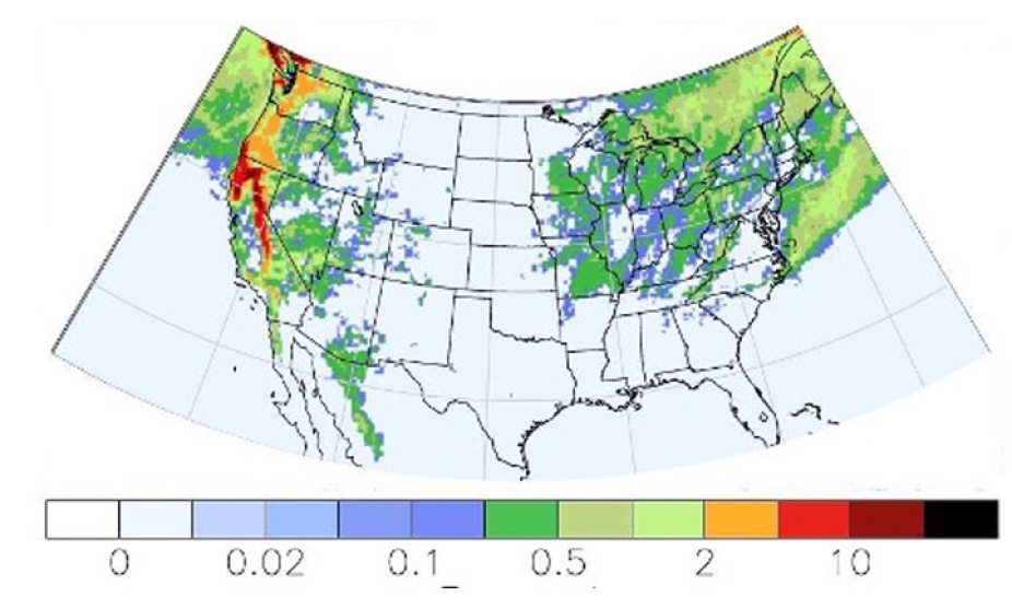
Fractional occurrence of graupel as a percent in a 14-km refined-mesh global simulation capturing heavy orographic precipitation in California
A critical challenge in climate and hydrological research is predicting the distribution of extreme weather events (severe thunderstorms, mesoscale convective systems, tropical cyclones) and their impact on the hydrologic cycle. Hydrological extremes in the form of floods or droughts are critical in environmental prediction across spatial and temporal scales, particularly for seasonal and longer timescales. There is a critical need to understand the risks from flood and drought and how these may vary from region to region. The driver of both, precipitation, can be difficult to assess and predict, as its forcing and mechanisms span many scales: from those of cloud microphysics (micron) to organized convection (<1–100 km) to synoptic systems (o100–>1000 km).
We are at an exciting juncture where new ideas and methods from atmospheric and climate science can be brought to bear on accurately predicting precipitation for hydrological questions. The push toward simulations of ever-higher resolution demands accurate representations of precipitation processes, which in turn involves the explicit capture of cloud dynamics across weather scales. For example, the figure above shows the frequency of occurrence of graupel, an indicator of potentially intense precipitation, in a global climate model (CESM2) with modified cloud microphysics run on a mesh refined to 14 km. This is an attempt to duplicate the features present in mesoscale weather models, but in a climate model and at timescales relevant for climate studies, with this being a multi-year simulation.
Weather models (e.g., WRF) are being used in similar fashion to simulate high-impact weather at convective-permitting resolutions (e.g., <4-km grids) over seasonal to annual time scales. While able to provide great weather detail, these model setups generally do not include coupling to other earth system components. As such weather model applications would also need to function faithfully over long timescales, the SIMA framework can integrate evolving land and ocean surfaces, conservative transport, and closed energy budgets essential for extended-period simulations. Thus, there is benefit in combining the ongoing efforts of weather and climate model development at NCAR. SIMA’s advanced atmospheric components that can simulate down to the convection-permitting scale will be a powerful tool to explore weather extremes of the future.

SIMA schematic for a climate investigation configuration with the Spectral Element (SE) dynamical core run with a refined mesh, CAM physics, and aerosols in MUSICA (Multiscale Infrastructure for Chemistry and Aerosols). Such a configuration could also use modified weather model physics. For the simulation of weather extremes, full chemistry is not necessary
Configurations

15-3-km refined mesh over US (MPAS)
- Peter Lauritzen
- Bill Skamarock
- John Truesdale
- Michael Duda
- Miles Curry

~5-km refined mesh over S. America (CAM-SE)
- Patrick Callaghan

Global uniform 4-km CAM-MPAS mesh (Earthworks– MPAS)
Ex: Earthworks Project MPAS configuration for high-resolution global simulation (4-km MPAS-A, global, non-hydrostatic setup) (Image courtesy Falco Judt, NCAR-MMM)